


Timeline of Events of the Hill Country Floods on July 4th, 2025
A full breakdown of the events of the flooding on July 4th, 2025

After catastrophic flooding in the Texas Hill Country, there have been many questions about what warnings went out when and exactly how much time those warnings gave individuals to move to higher ground in the areas primarily impacted by the floods.
On July 3, 2025, the NWS issued a flash flood watch for a large portion of southern Texas at 1:18 PM. The discussion issued along side the flash flood watch indicated rainfall rates that would be in the range of 2-3 inches per hour.

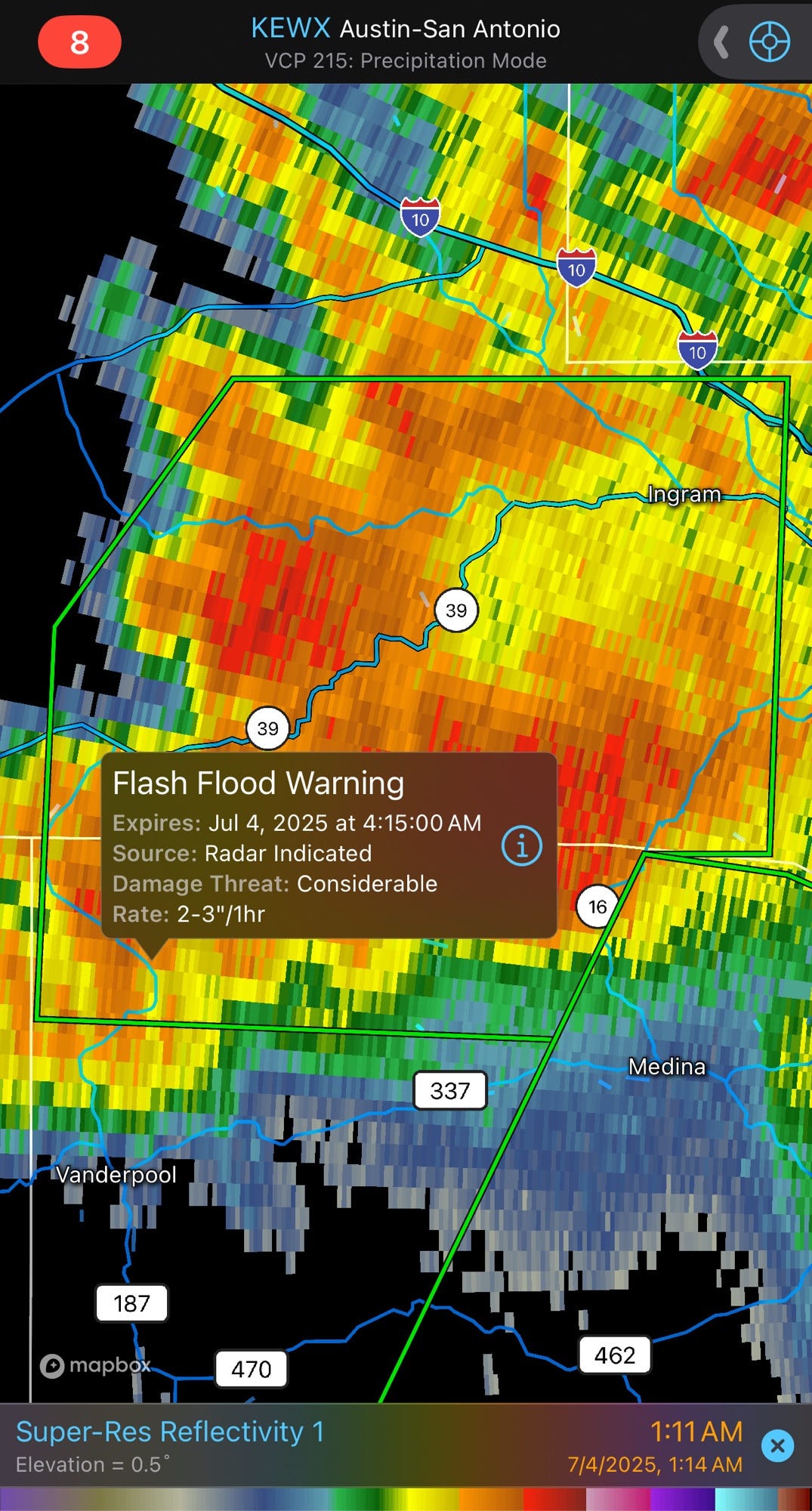
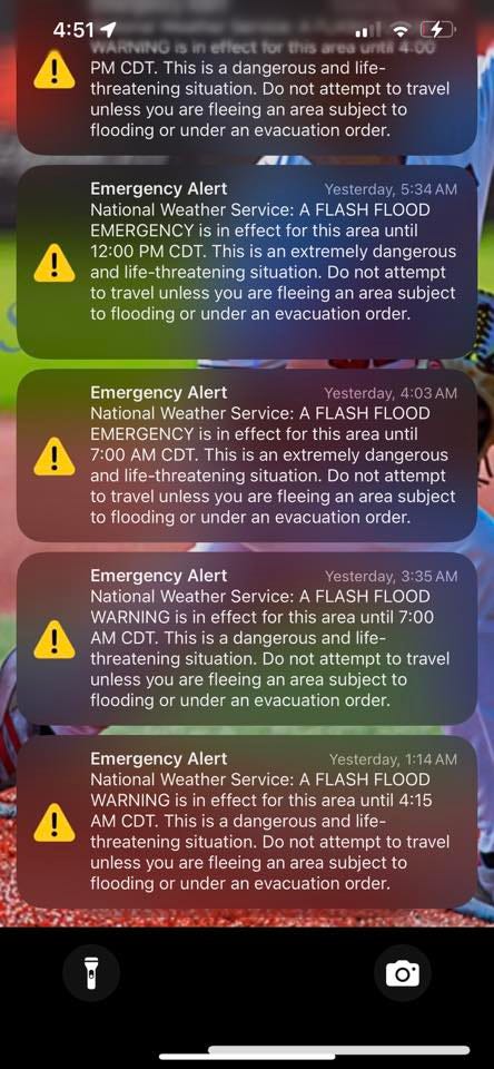
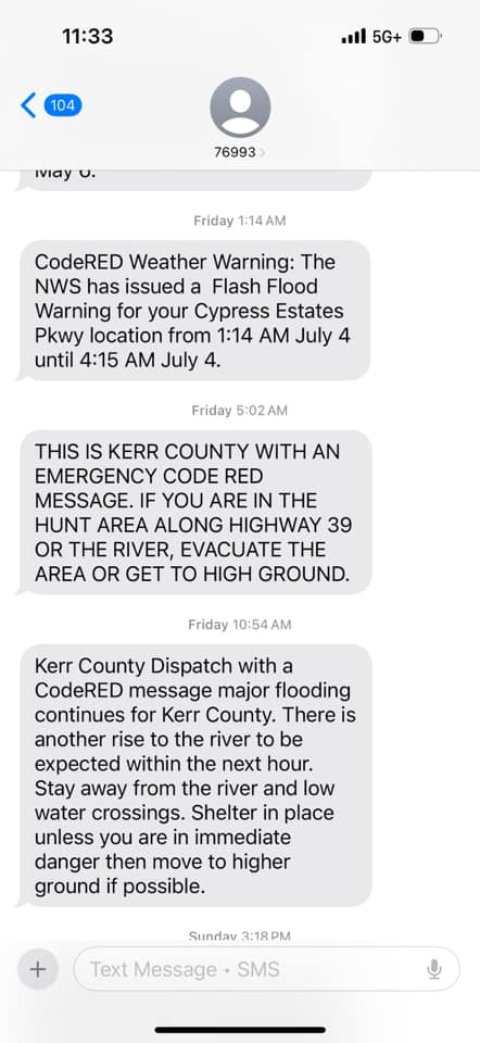
The first flash flood warning issued for specifically Kerr County was at 1:14 am on July 4, 2025. This was issued as a Considerable flash flood warning so a Wireless Emergency Alert (WEA) was sent with the issuance of the warning. You can see the area of the the warning below as well as a screenshot of the WEA with the time. This initial flash flood warning was set to last until 4:15 am with rainfall rates estimated to be 2-3 inches per hour.
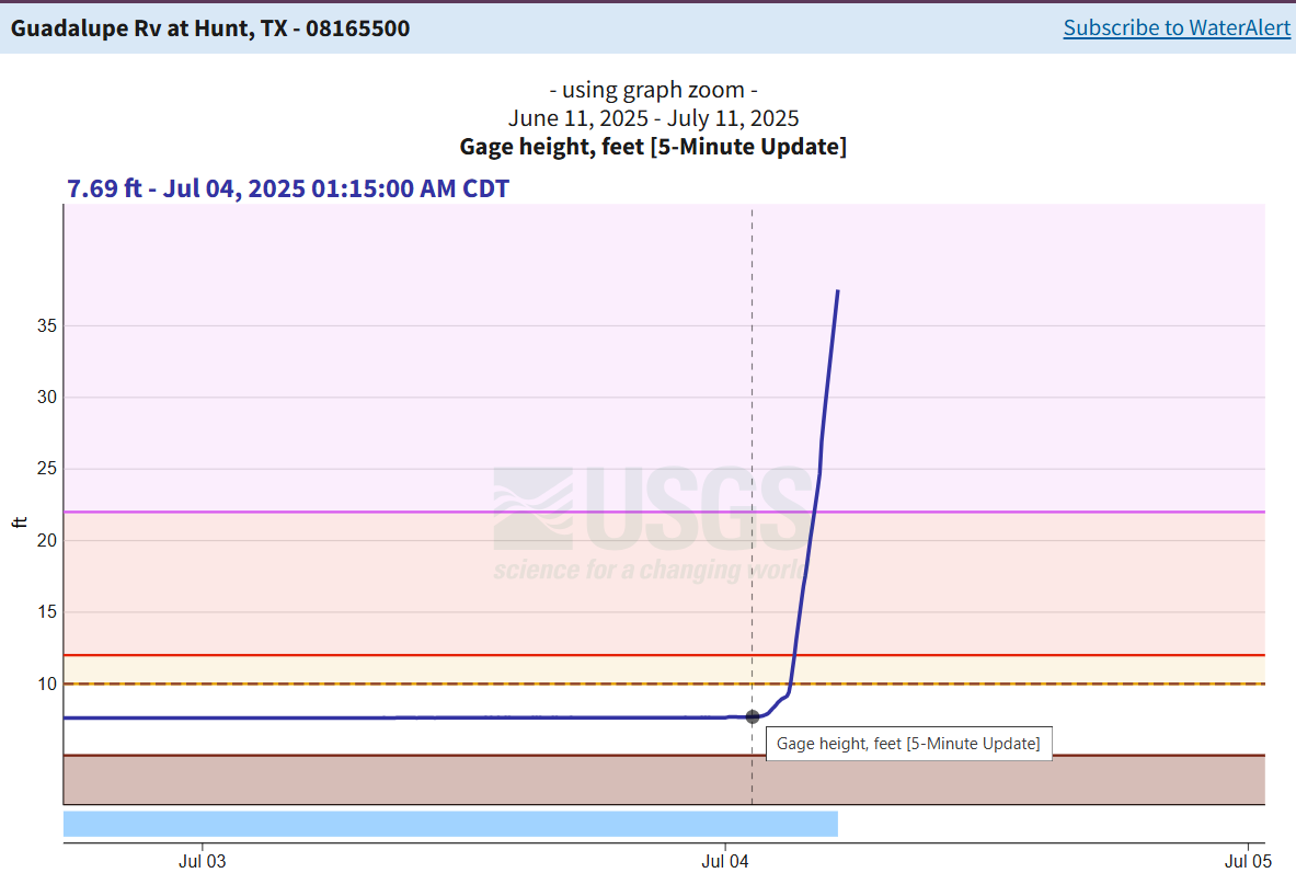
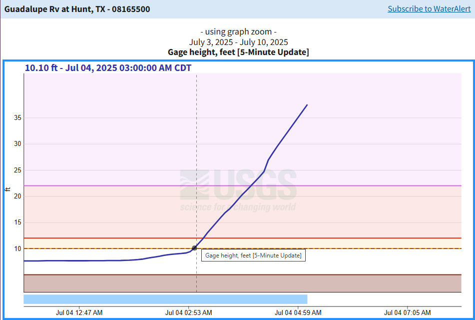
At this time, 1:15 am or so, the Guadalupe River in the area of Hunt, Texas was still at its normal river height of 7 and a half feet as shown in the screenshot of the river gauge below.
Additionally at this time, Kerr County’s CodeRed system sent out an automated text message indicating the flash flood warning had been issued by the NWS as seen in the screenshot below.

So let’s look at the area of Camp Mystic.

This gives you a general idea of the layout of the camp. On the left side, were the younger kids’ cabins. On the right side were the older kids’ cabins.
The river is on the north side of the camp, so this image is facing south to give you some orientation.
The next image will be a topographical map of the area in meters because the only map that actually shows where the cabins were located properly is in meters sadly.

The Guadalupe in this area is at about 553 meters above sea level. That means the top of the Guadalupe is at about 1816 feet above sea level. Now flood stage for this area of the river starts at 10 feet. The river normally runs at 7 feet. Flood stage means that is the level the river has to reach to begin threatening structures in the area so we’re looking at starting all of our calculations at about 1819 feet above sea level.
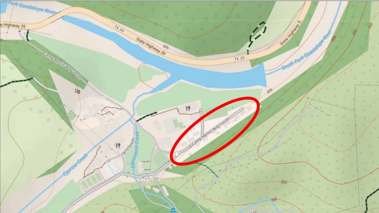
The area we are going to be focusing on is on the far right end of Camp Mystic circled in red below. This is where the smaller children at camp slept. This area of camp sits at an estimated 1839 feet above sea level. Meaning, that when the Guadalupe reaches a flood stage of 20 feet above the baseline flood level, the cabins will begin to be flooded with water.
With the first flash flood warning at 1:15 am, the river did not reach flood stage until 3:00 am.
At that first stage, the initial floodwaters would likely not have encroached very far into the camp itself.
By 4:05 am, the river had reached major flood stage which is approximately 22 feet, or 12 feet above flood stage.

This means everything up to 1831 feet would have been at least partially underwater. This includes the dining hall that has been heavily photographed after the floodwaters receded missing a wall. You can see an estimated breakdown of where that is below.

It was also right around this time that the NWS San Antonio office issued a flash flood emergency for flash flooding causing catastrophic damage.
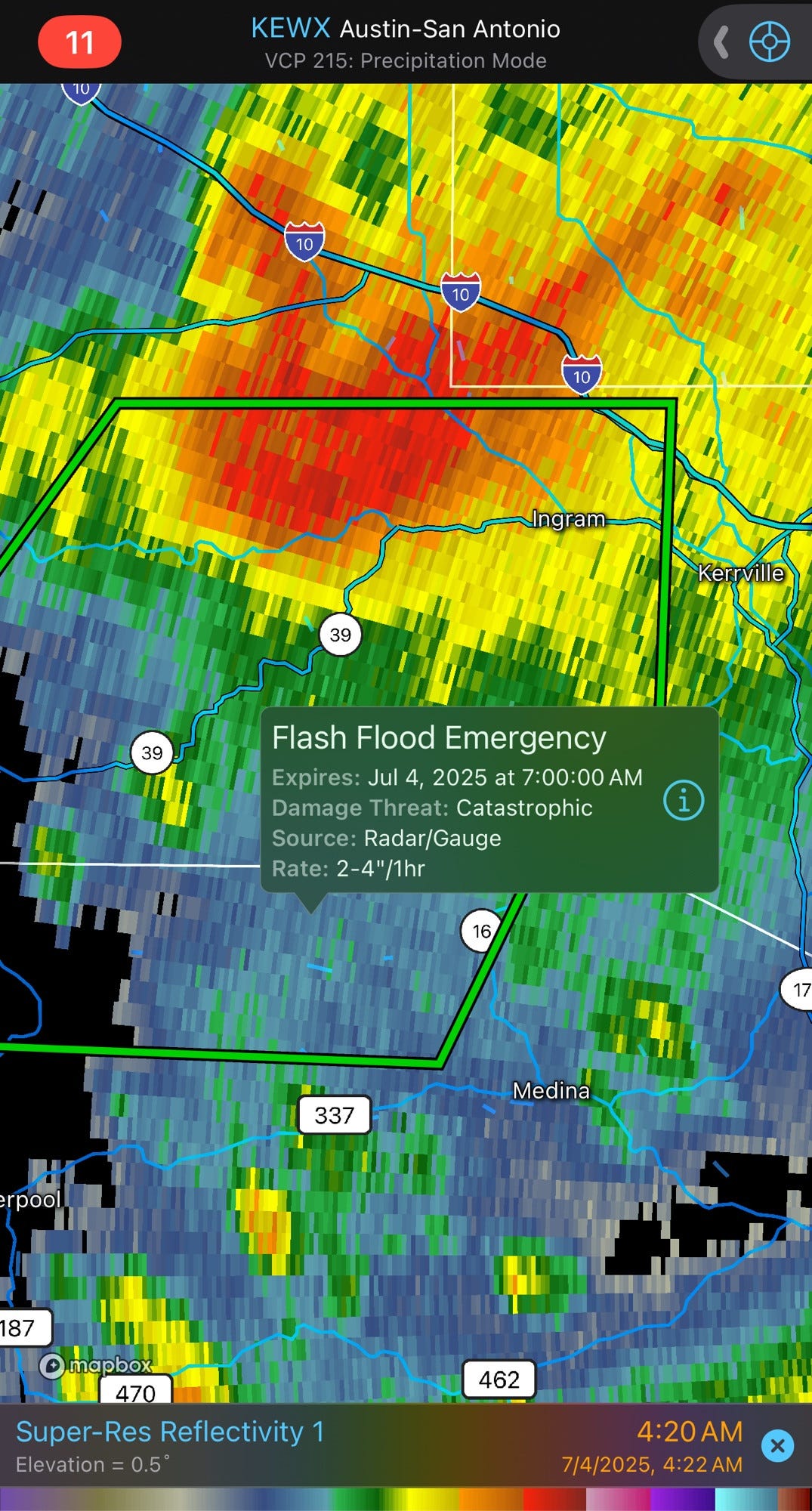
It is important to note that the local officials in Kerr County where Camp Mystic and all of the campgrounds in this area are located, has not yet issued any official communications at all. No evacuation orders or requests, not even a mention that flooding was actively happening. Nothing.
At 4:35 am, the river hit that 20 foot level above flood stage I talked about earlier. This is when floodwaters would have started inundating the cabins that the 8-9 year old girls were located in. It also would have started flooding the other areas of the camp beyond the dining hall. Anything below 1839 feet sea level elevation would have been subjected to floodwaters at this point. You can see an estimated extent of that flooding below.

After this, the river continued to rise until 5:10 am before the river gage was washed away by the flood. The max it hit was 37 feet. That is 27 feet above flood level meaning everything below 1846 feet sea level was at least partially inundated with water. You can see an estimate of that below.

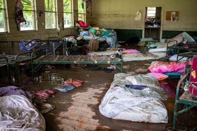
The height of this makes sense as in photos you can see below, it appears the cabins sat approximately 1 foot off the ground due to foundation and then the water lines inside the cabins from the flooding themselves are approximately 6 feet from floor level. If the average cabin is at 1839 feet elevation, there would be 7 feet of extra water flowing into the cabins.
Now just prior to this, Kerr County issued their first alert to the county from officials. It went out as a CodeRed alert and read as below.
Camp Mystic is right along highway 39. But as we’ve shown above, by 5:02 am, the river was at least 35 feet, well above flood stage and many people had already been swept away by the floodwaters.
Additionally, there was no notification anywhere else from Kerr County authorities until nearly 5:30 am when both Kerr County Sheriff’s Office and Kerr County itself posted these two posts.


We know the county was aware of the flooding by at least 4:20 am because a volunteer firefighter in Ingram, Texas contacted Kerr County dispatch to request they issue a code red alert as a street sign he was near was completely underwater. Dispatch said they needed additional supervisor approval to issue the alert. It would take at least an extra 30 minutes to receive that alert to any phones in the Hunt, Texas area. In which time the water went up at least another 11 to 12 feet.
The National Weather Service can only do so much in this situation. They issued their WEAs in a timely fashion with plenty of time for evacuations to be ordered for all the areas impacted to receive them. In fact, I would argue they issued them in enough time that sheriffs could have driven to the various camps in the area in order to tell them in person it was time to evacuate. But critical delays in issuance of evacuation and emergency notifications caused the major loss of life incurred here.
Thank you for pulling all this together, including the topo maps. Very helpful.